Live Traffic Report
Real-time Traffic information in today’s Live Traffic Report
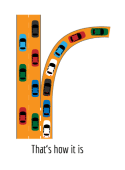
How modern GPS apps use Big Data for route guidance and traffic jam avoidance. Overview of the current state of technology of GPS apps and real-time traffic information used in the live traffic report like the one here we devolped.
Development of Live Traffic report
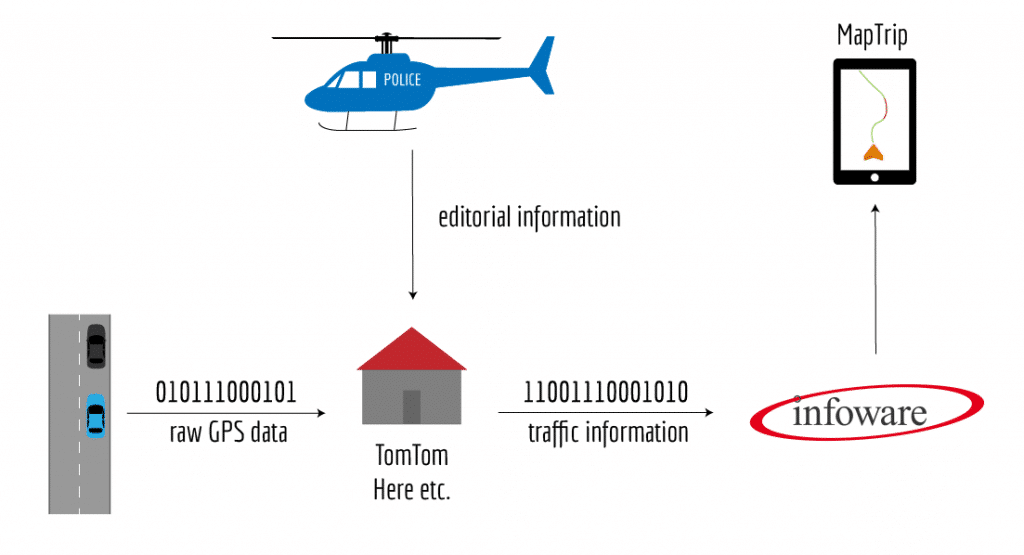
Real-time traffic information has developed significantly in the last few decades. In the early days, only notifications from the police or ADAC (the German equivalent of AAA) were read over the radio. Then induction loops, sensors on bridges, and the transfer as data streams to navigation systems were added. A watershed moment came with the transition to crowd-sourced big data, in which a huge amount of raw data from smartphones and cars is used to paint an unparalleled detailed picture of the traffic situation. For navigation software this means a big change in live traffic report, which we will showcase at the example of MapTrip.
Real-time Traffic information in the past
In the old days, live traffic report, what was understood as live traffic report at this time, was only read back on the radio. “Traffic is backed up for 5 km on the A3 between x and y due to an accident.” You had to listen intently while driving to determine whether you were affected or not. If you were, the passenger had to pull out a map and possibly look for alternative routes.
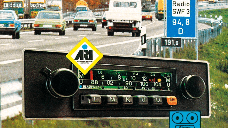
The live traffic reports were announced and cancelled with the so-called Hinz trill, by which the car radio recognized a traffic report as such. The Hinz trill could also be combined with other melodies of the respective radio station.
Traffic information was primarily disseminated by the police and ADAC back then, to which sensors on bridges and induction loops embedded in the road were added later on. If the police was called to an incident, they would report the status to the traffic editorial offices of the local radio stations, who would then read the information in the next broadcast. Consequently the traffic information was not real-time at all and no comparison what we understand nowadays under live traffic report.
The first navigation systems with traffic information used so-called TMC messages. These were basically the same editorial traffic jam notifications that were read on the radio, and they were also transmitted by radio. The difference was that these messages could be received by a navigation software and automatically displayed on a map and factored into the route planning.
This was a major step for navigation systems. But we all experienced first hand just how deficient this technology of live traffic report really was. You could spend hours in a traffic jam while the navigation system would have you believe that the road was wide open. Or the navigation system would guide you around a jam through the most absurd detour, even though the congestion was long gone. There was plenty of frustration to go around, yet still everyone wanted to have the traffic info.

Traffic information todays live traffic report
As smartphones became the norm, entirely new perspectives for generating traffic information emerged. The pioneer was TomTom in 2008. The locations of mobile phones were pin-pointed in a collaborative effort with Vodafone. This information revealed how traffic was moving along on the freeways. Merged with the traditional TMC information, it was thus possible to better map out the overall live traffic report.
Crowd-sourced big data for live traffic report
Eventually a different process prevailed, which did not require the cooperation of a mobile phone company. Instead of pin-pointing a location in the cellular network, so-called Floating Car Data (FCD) was used. This required a large number of smartphones to regularly disclose their GPS position. If the number of participating phones is large enough, the actual traffic situation can be ascertained with a high degree of accuracy. This is a textbook big data application. The more raw data available, the better for live traffic report.
Free navigation apps as a data source for live traffic report
It is this principle why navigation apps are free to use. Google Maps, Here Maps, or Waze (also owned by Google) are basically apps that collect data. During use, the apps send GPS positions, i.e., floating car data, back to the companies, who then use this information as an additional ingredient to generate traffic information for the use in live traffic report.
For live traffic report on freeways it is relatively easy to generate traffic information from GPS data. But in inner cities the challenge is to distinguish the GPS data from pedestrians to people who are in their car but stuck in traffic. So the source that is used for the raw GPS data is imperative. If a lot of data is used from taxi fleets, for example, you can expect good coverage of the inner cities, but the challenge then is to avoid showing the wrong status at taxi stops. If a lot of raw GPS data is obtained from trucks, you can expect good freeway coverage in your live traffic report, but not inner cities.
This is one of the challenges that traffic information providers have to deal with. They have to make sure that they have a balanced mix of sources for their raw data. But we believe the most important aspect is the sheer mass of raw data.
Google does it with mass
This is why all roads lead to Google. With its Android operating system, Google has by far the largest source of GPS raw data for live traffic report – here floating phone data – available. Off the record, many navigation specialists from BMW, VW, or Mercedes will admit that – in addition to their proprietary built-in navigation system – they also have Google Maps running as a backup. Unfortunately, Google’s traffic data cannot be used separately, as the company does not make it available.
Here and the automotive industry
Another player on the market that is of great interest to us is Here. Through the acquisition of Here (formerly Navteq) a few years ago by a consortium of the German automotive industry, all sensor data of the cars is accessible in theory. Very accurate information about the speed, weather, speed limits, or icy roads is available. We can’t wait to have access to the Here data and integrate it in MapTrip! (Update 2021 — Here data is available — please ask our sales team).
Many ingredients for the best live traffic report
Today, traffic information that is generated redactionally is on the fringes. But it still matters because it offers people important contextual information. There’s a significant difference between a traffic jam being caused by a construction site, icy roads, high traffic volume, or due to a road closure. This is why even today, automatically generated traffic data is still supplemented with editorial live traffic report.
Mode of transmission
Live traffic report in the Radio
TMC messages can still be received over the radio. This is an attractive solution for some users in the field of telematics as it is the most cost-effective way to get live traffic report. But this means of transmission is very limited and not suitable for the vast amount of traffic information transmitted today.
Live traffic report by Internet
MapTrip and other modern navigation systems use internet connections to obtain traffic information for their live traffic report. The transmitted data volume still plays a critical role in the professional environment and in large fleets. But it is important to intelligently select the information that is actually needed and use data compression algorithms to reduce the cost of transmitting the data to a minimum.
How does the navigation system get traffic data?
Live traffic report in the future
We believe that traffic data will continue to evolve significantly. On the one hand, the quality of traffic jam information can still be improved, and on the other hand the data can be enhanced far beyond mere information about jams to all relevant information for drivers.
Currentness, coverage, and accuracy
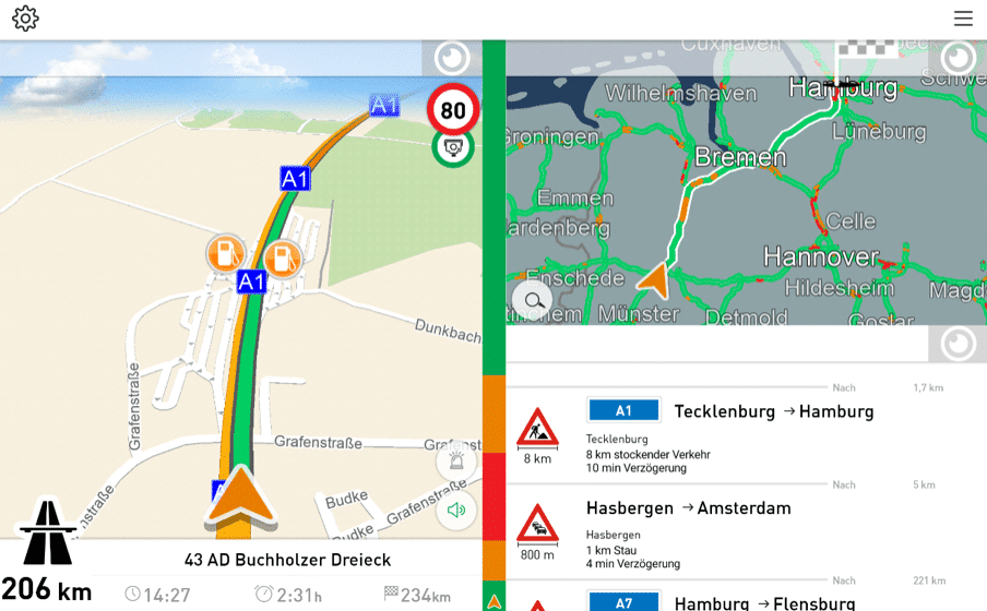
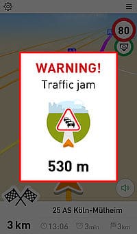
The faster a traffic jam is recognized and pictured as this in live traffic report, the better it is. But for navigation it is also important to know where exactly the jam starts and ends. In MapTrip, we are already analyzing the speed of traffic on the freeways. If speeds drop off significantly on short routes, we interpret it as the far end of the traffic jam and MapTrip issues a corresponding warning. The more accurate and current the information, the better the warning works.
Traffic data from freeways is the easiest to work with, as the highest volume of floating car data is available in this case. But it is also becoming increasingly important to have traffic information available in inner cities in order to to provide the best live traffic report and find optimal routes through the traffic jungle in urban areas. Today, this already works quite well on the major roads of big cities. But more and higher quality data is always welcome here too.
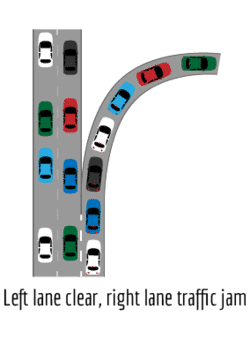
Lane-accurate traffic data to be reflected in live traffic report?
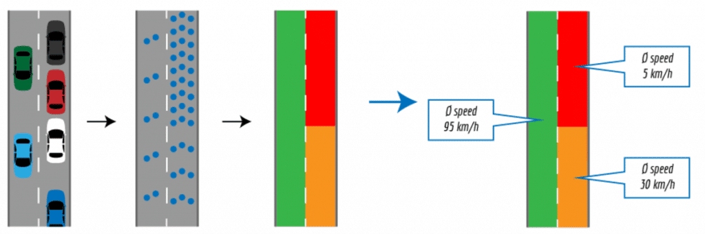
Our request to traffic information providers: On a freeway intersection, trucks are getting backed up in the right lane, while traffic is flowing freely in the left lane. In this case, the providers of traffic data generate a mean value from the stationary trucks and the flowing traffic and output a traffic jam for this section of the freeway. This information is wrong whether you are driving straight ahead or whether you want to turn right.
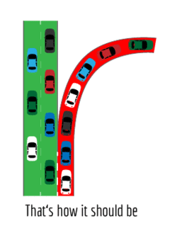
Lane-accurate traffic information would much better reflect reality:
Rain, ice, fog
In the future, traffic information will encompass much more than just describing the traffic situation. Networked fleets of vehicles can, e.g., provide information about rain (windscreen wipers on) or fog (fog lights on) via the cloud. Even icy road conditions could be reported to other road users by identifying when the ABS system engages in other cars.
Prediction
Road traffic is very dynamic. As all commuters know from experience, it can make a world of difference whether you leave for work at 6 am or 6:15 am, or whether you drive home at 4:15 pm or 4:30 pm. For us as a navigation software developer, it means that the driving time calculated by MapTrip is most likely precise at 6:15 am, but it may be completely off for 6:30 am. Even though our algorithms already take account of the likely development of traffic, the data does not accurately reflect the reality during these dynamic phases. We hope that the providers will be able to offer significant improvements in the future.
How MapTrip uses traffic information in their live traffic report?
As discussed above, traffic information is no longer about local disruptions. In the past, the information was received directly by the navigation devices and used to calculate the route. But today, traffic information is a multi-dimensional universe of information, consisting of current, static, and prognostic data. And additional information, such as speed limits, weather conditions, or road conditions is also included.
This flow of information cannot be sensibly processed on mobile devices. The transmission or computation capacity of smartphones or navigation devices would simply not suffice.
This is why we decided on a server-centric architecture for MapTrip. The MapTrip backend is continuously fed with the most up-to-date traffic data and can thus calculate the best possible routes. The navigation software in the car only sends route inquiries to the server and receives the finally computed and optimized routes back from the server. This approach has the advantage that the server can inform the navigation system about faster routes at any time.
Overview of advantages:
- Optimal routes and precise arrival times as all traffic is taken into account. (Calculation on server)
- Minimal use of resources on the mobile device (thin client) as complex calculations are handled by the server.
- Maps are always up-to-date as the servers continuously receive updates.
- Road data stored locally on the mobile device also enables offline navigation when needed (without live traffic report in this case)