MapTrip GPS Navigation SDK
Integrate truck navigation for your app in just one day. The MapTrip Navigation SDK provides all important functions ready to use.
Integrate GPS navigation functions directly and conveniently into your own app. The SDK contains lots of explanatory demo source code, documentation, map material and access to the MapTrip backend. Unlock the power of professional GPS navigation in your application!
GPS Navigation directly in your app

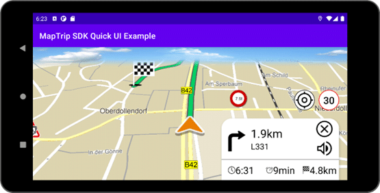
The MapTrip GPS Navigation SDK is an easy-to-use library that you can use to add GPS navigation functions to your app. You don't need to be a GPS navigation specialist to do this. In just one day, you can integrate a map with route calculation and driving announcements into your app. The MapTrip GPS Navigation SDK provides you with the most important functions ready to use.
- Map display
- Route calculation
- Spoken driving instructions with street names
- Route information: remaining distance & time, ETA
- Next instruction: direction and remaining distance
- Speed limit display
- Automatic switching between day and night mode
- Button to resume location tracking
- POI display: Traffic events, traffic flow & speed cameras, truck restrictions
- Setting options: Sound output, TTS, day/night mode
Documentation and Tutorial

You can find the full developer doc here.

Our tutorial explains the basic concepts of the MapTrip Server-API and illustrates them with examples.

On our YouTube channel you will find numerous videos on development topics.

On Github you can find useful hints and examples.
Core SDK Features at a Glance
The MapTrip GPS Navigation SDK offers you easy to use modules which handle all the core features of a Truck GPS app. This allows you to concentrate on the optimal adaptation to your application.
Map Display
You can easily integrate a map in your app to show the vehicle's location, the route and your own POIs, if you like. The live traffic conditions can be superimposed in green / yellow / red shades. Map colors and level of detail can be manipulated.
Traffic Information
Traffic information is considered in the route (if calculated online on our servers). It also comes as an overlay for map display to display the live situation in green, yellow and red. Traffic events can be superimposed as POIs on the map and are also available as lists with detailed information. All traffic information requires an online connection to our servers.
Route Calculation
To calculate a route you need to specify the destination, vehicle type and truck dimensions and restrictions you might want to apply (such as avoid toll roads). Depending on your settings the route will be calculated on the device or on our servers. If the vehicle deviates from its route, a new route is requested by the SDK automatically.
Turn by Turn Voice Guidance
Once the route is calculated, you can start the guidance. The map is centered automatically to the device's location and the route is displayed. Information like ETA, distance to next maneuver etc. are provided as call backs. You can create your own guidance dialog or use our sample app as a blue print.
Is the SDK the right choice for me?
Is the SDK the right tool for your development goal or is using the MapTrip API the better option? The following points might help you decide what the best solution is for you.
The MapTrip GPS Navigation SDK is the right choice for you,
- if you want to add GPS features to your own application.
- if you want to create your own user interface and workflow.
- if you do not want to run an additional and seperate application.
- if you want to install and manage only one application.
The MapTrip API might be the better choice if you
- if you like the MapTrip app and feel that it covers your requirements.
- if running two apps in parallel is not a problem.
- if want to achieve quick results with little effort.
Truck GPS Navigation
The MapTrip SDK offers all features of the GPS app MapTrip Truck. With the truck vehicle profiles ETA and drive time will be calculated accordingly. Also vehicle dimensions, blocked roads and parking spaces are considered.

Live Traffic Data for Truck GPS
We use the latest traffic reports from TomTom and Here for navigation. The congestion information is processed in our backend and used to calculate the optimal routes. The GPS SDK automatically accesses this data during destination guidance. As a developer, you don't have to deal with the details of traffic information. The SDK automatically ensures that your app always gets the optimal route in all traffic conditions.
Online and Offline Navigation
The MapTrip GPS Navigation SDK can be operated with or without an online connection. All Traffic features require an online connection. The core GPS navigation functionality can also be provided if the map data has been stored locally on the device. There are three modes:
Online only
An internet connection is required for operation. This mode is recommended if you have to install the app over the air and want to avoid copying large amounts of map data via a mobile data connection.
Offline only
All map data must be installed on the device. Traffic data and other dynamic data such as fuel prices are not available.
Hybrid on/offline
The GPS app uses the online services of our servers by default. The complete set of features is available to the user. As a fallback the app can use its onboard map data in case the online connection fails.
Road maps
You can use our navigation SDK with maps from TomTom, Here or Open Street Map (OSM). All road maps include truck attributes such as length, width, height, tunnel codes or information such as environmental zones. You can test our MapTrip GPS navigation app free of charge with data from TomTom. Depending on the application scenario and area of use, it may be advantageous to use the road maps of other providers.
The map source is irrelevant for the development of your navigation functions with the navigation SDK. The SDK behaves in the same way with every type of road map. Differences are usually found at the map data level, where e.g. cycle paths are recorded in more detail in OSM than in TomTom or Here. Forest paths are also included in OSM in greater detail, so that navigation applications for these areas find a good database with Open Street Map. Truck attributes, on the other hand, are more complete and reliable in TomTom and Here. The developer of a truck GPS navigation system should therefore first take a close look at this map data.
![]()


Documentation of the GPS SDK for Truck
The SDK contains extensive documentation and a steadily growing number of sample apps.
- A mini GPS navigation app serves as a blueprint and can be used as a quick start for your own development.
- You can find demo apps on our GitHub account.
- We post how-to videos on our YouTube channel.
Changelogs
We are continuously developing our Navigation SDK. In the changelogs, we present the new functions and explain the use cases that led to their development.
Platforms / Operating systems
The MapTrip GPS Navigation SDK is essentially developed in C++. With the help of so-called wrappers, versions for the following platforms and operating systems are made available.
- Android
- Windows
- iOS
- Linux
The functional scope of all SDK versions is identical.
Cross Plattform Navigation SDK z.B. Flutter
Cross-platform development kits can be used to create apps for Android and iOS, for example, from a single code base. The MapTrip GPS Navigation SDK provides so-called wrappers for Android and iOS. Our developers will be happy to help you use the GPS Navigation SDK in cross-platform environments such as Flutter.
Edit street maps
The additional Detour function can be used to edit, delete or add to road maps. Detour is used by fire departments, for example, to edit passage widths or to add missing roads. Preferred routes can also be defined and driving speeds influenced (Guided GPS Navigation). We provide the Detour Editor for editing road maps. The changes are automatically adopted by the SDK for each client.
Find out more about Detour here.
FollowMe for waste management, street cleaning, winter services
The additional FollowMe function is available for applications in waste management, street cleaning and winter road maintenance. The function is also included in the navigation SDK and ensures that a predefined route is followed precisely. The route can be as complex as required and can contain individually added driving instructions.
The routes can be imported or created manually using the FollowMe editor. The routes are automatically synchronized with the navigation SDK.
Find out more about FollowMe here.