Explanation of the Detour technology -
Adaptation of map data for GPS navigation and route planning
Find out more about the unique and innovative Detour technology, its key functions and versatile areas of application on this page.
What is Detour technology?
Detour technology offers a comprehensive solution for independent adaptation of the GPS navigation map and routes for different vehicle types and needs. It enables almost all conceivable individual changes to the road maps - which are then immediately taken into account in the GPS navigation.
The changes are automatically synchronized with the MapTrip 112 GPS navigation apps. Devices with MapTrip 112 GPS navigation automatically receive the changes and they are taken into account when calculating the route, i.e. they are bypassed accordingly or the road is included in the route guidance. The changes are also displayed to the driver on the navigation map.
Detour is an optional function that can be added at any time and is suitable for various telematics applications in logistics or for the fire department. The Detour technology is extremely helpful for journeys in the BOS (Authorities and organizations with security tasks) area, as special GPS navigation requirements apply here in particular, but it also offers dispatchers a way to easily and conveniently adapt the map data to their own circumstances on the screen in regular day-to-day haulage operations.
What are the main functions of Detour technology?

Close roads depending on direction and time
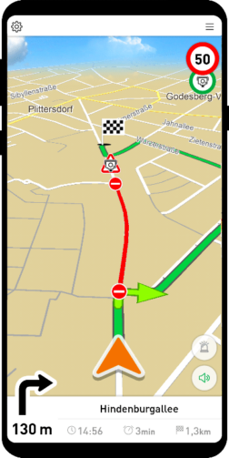
You can use this function to block roads if, for example, there is a roadworks site or a daytime closure due to a demonstration. You can also set up recurring closures, e.g. if a street is blocked every Wednesday by a weekly market. Or simply if you know that the road is too narrow or unsuitable for your operation. You can specify the duration (day and time) and direction of the closure.
Unblock / open roads
BOS vehicles can, for example, unblock the direction of travel against a one-way street or the passage through a pedestrian zone. The routing server will include the section you have unblocked in the route calculation.
Prioritize or avoid roads
These functions act like a magnet on the route guidance and can be used, for example, to define a specific route to a logistics center or to avoid a road with lots of potholes. Or to mark faster routes as preferred routes based on experience. Other roads where there is a high risk of delays can be marked as to be avoided. In this way, you can ensure that the navigation system takes the same good routes as an experienced driver with years of local knowledge.
Deactivate or add turn restrictions
Another important function is that you can switch off individual turning regulations. If, for example, only "Straight ahead" and "Turn right" apply at a junction, you can specifically switch off the rule. The route calculation will then calculate a route that also takes into account "Turn left" at this point.
Edit and add truck restrictions
Truck restrictions are stored in the map data. They contain information such as the height of a tunnel, the maximum weight that can be driven on a bridge or the width of a road. You can edit these yourself using Detour technology. Missing restrictions can be added.
Add missing streets
With its Detour technology, MapTrip is the only professional GPS navigation system to offer the option of simply adding missing roads to the map data yourself and sending them directly to the navigation system. This means that missing roads, e.g. in new development areas, on company premises or a route to a logistics center, can be added at any time.
Dividing roads
In order to close only part of the road during roadworks or other temporary restrictions while the other section remains open to traffic, the roads can be divided using Detour technology. In other words, if there are roadworks and you only want to close one branch of the road so that you can still drive into the road from the other direction, you can split the road and close one section.
1-n Resource preselection - Only with the server API
Using the ETA query in combination with a distance matrix calculation, you can determine at lightning speed which vehicle can be at the scene the quickest and alert it accordingly. All previously entered closures are of course taken into account.
Advantages of Detour technology:
Complete flexibility:
Enables the adaptation of navigation maps and route planning for different vehicle types and needs. The changes can be used directly and "on the fly" in MapTrip GPS navigation and also in MapTrip route planning, resource planning, etc.
Time saving:
Detour technology enables the fast and precise adjustment of turn restrictions, truck restrictions and other map details without having to wait for new map data deliveries. The long wait for a new release from the map data manufacturers is eliminated.
Security:
Detour technology significantly improves safety in route planning. With the ability to block roads, disable turn restrictions and edit truck restrictions, drivers can be sure they are always using the optimal route. This minimizes the risk of vehicles getting stuck in roads that are too narrow or having to take an unnecessary detour. Detour technology therefore not only ensures efficient routing, but also the safety of vehicles and drivers during the journey.
Easy to use:
Available options such as the MapTrip Detour Editor web application enable simple and intuitive manual editing of road data without the need for development work.
Automatic synchronization:
Changes to the navigation maps are automatically synchronized with the MapTrip 112 navigation app, displayed on the GPS navigation map and taken into account when calculating the route.
Offline use:
An Internet connection must be available for synchronization (e.g. if the vehicles are in the hall), but the changes are then also taken into account offline in the GPS navigation.
Increased efficiency:
Routes can be optimized and journey times shortened by adding, blocking, prioritizing or avoiding roads.

What options are available for integrating MapTrip Detour technology?
All options offer the same comprehensive functions for editing road maps.
Without development work:
MapTrip Detour Editor web application - for manual editing of road data in the Internet browser. With no installation required, the editor is ideal for all organizations that do not require any development effort and want to use all the functions of the Detour technology directly.
You can also find out more on our page: First steps in the Detour Editor.
- Android interface - The MapTrip app itself has an interface to communicate with other Android apps. As a developer, you can use it, for example, to start navigation, define the dimensions of your vehicle or query the calculated arrival time.
- MapTrip SDK - is a development kit with which you can develop your own navigation. Of course, you can also use the Detour functions here. The changes are made in the Detour editor and then automatically adopted by the SDK for each client.
- ServerAPI - provides the ideal link between the navigation and the control center. This allows routes to be planned precisely in the control center and then sent directly to the navigation system in the vehicle. A route calculated with the server API can also be visualized by the dispatcher in the control center in the editor and edited manually before it is sent to the navigation system. This is possible because the data formats generated by the server API can be seamlessly used in MapTrip Navigation and in the editor. The routes in the navigation then correspond 1:1 to those in the control center.
Using the server API, developers can also import local information about the road network into the navigation. This can be, for example, a directory of all roadworks that already exists in the control center.