Map data
Add missing streets in the map data and see them directly in the navigation!
As the only professional GPS navigation MapTrip offers the possibility to easily draw missing roads on the map yourself and send them directly to the GPS navigation.
Problem: there is no possibility to add missing streets to the map data and see these street immediatelly in the GPs navigation
You know this yourself, sometimes roads in new construction areas, access roads or roads on company premises are missing in the GPS navigation. The possibilities to change this are currently very limited. You can report a missing road to the map providers like TomTom, Here or OSM, and hope to find this road again in the next map release. With a well-known, free car GPS navigation, you can draw in roads yourself, but these are only transmitted to the map provider. You still won’t see this road in your GPS navigation device for a long time.
Great demand
More and more, we received requests from our customers who wanted the same function. To add a missing street to the map data and to send this street directly to the GPS navigation. With the new version MapTrip 5.3. exactly this is possible.

Mit dem Laden des Videos akzeptieren Sie die Datenschutzerklärung von YouTube.
Mehr erfahren
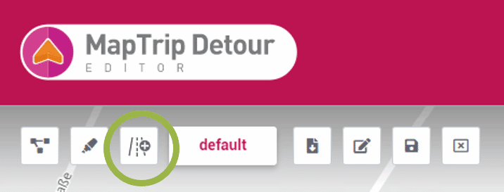
Functions in Detour Editor extended
To do this, a new button in the Detour Editor calls the function for drawing roads.
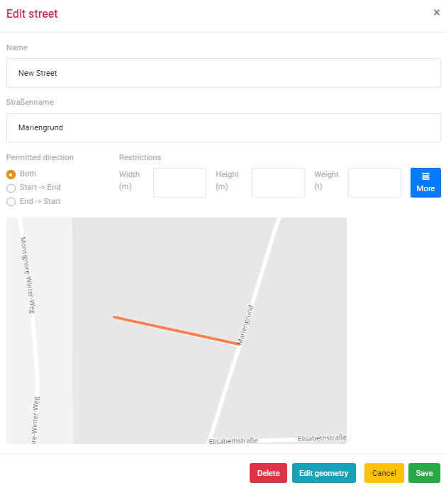
Then the new street is drawn into the map by mouse clicks and saved.
Synchronization is automatic and the new street appears immediately in the MapTrip GPS app.
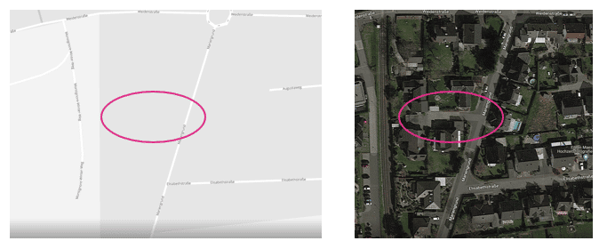
Example
This small road is not included in standard maps from TomTom, Here and OSM. Using the Detour editor, it can be added with a few clicks and sent to the navigation devices.
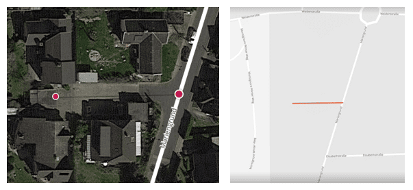
The missing road is added in the editor and is immediately available in the GPS navigation.
Typical use cases in the logistics sector
Of course, there are no limits here. As soon as a street is missing, it can be drawn in with the new function. This can be the case, for example, for new construction areas that are not yet included in the regular street maps from Tom, Here or OSM. But you can also add yard entrances to the public road network, approaches to logistics centers or add roads on a company site.
For emergency operations
A missing road is particularly critical when the fire department, ambulance service or police are on a emergency mission. Here it is particularly important that drivers can really drive along EVERY road in your operational area and reach every point at any time. Then simply adapt the map data to your specific needs and situations and use it directly in your MapTrip GPS navigation. The changes will be directly and “on the fly” usable in MapTrip GPS Navigation and also in MapTrip Route Planning, Resource Planning etc
What are the advantages of being able to add your own roads to the GPS navigation?
- Lengthy map setups and installing map updates are no longer necessary — you become completely flexible and independent of map updates from providers.
- You can react quickly — making a change takes just a few mouse clicks.
- The GPS navigation really knows every passable street and access road in your area.
- Even new roads and residential areas are immediately available in the GPS navigation.
- Drivers do not have to search for a long time, but are always guided on the best way.
- Your drivers are thus more efficient, faster, cost-saving, safer and energy-saving on the road.
Complete flexibility in map editing with Detour Editor
With Detour Editor you can not only add missing roads, almost all imaginable custom changes can be made to the road maps. The changes are automatically synchronized with your own MapTrip navigation apps.
The following changes can be made in the Detour editor for navigation and route planning:
- Edit and create truck closures (length, width, height, etc.)
- Block roads
- Open blocked roads
- Prioritize roads in route calculation
- Avoid roads in route calculation
- Disable turn restrictions
- Draw and add new roads
If you would like to learn more about the possibilities of Detour Editor, why not arrange a demo via web meeting with our GPS navigation experts. We are looking forward to your request.