GPS for Truck Routes
TIS-GmbH — Why MapTrip is the truck GPS navigation of the experts. Telematics solutions with integrated truck GPS navigation
We report from TIS GmbH in Bocholt, one of the market leaders for sophisticated telematics projects and what advantages they have through the integration of MapTrip GPS navigation software.
Why experts like TIS GmbH from Bocholt rely on integrated GPS navigation software
Just recently, the company TIS GmbH won the German Telematics Award 2022 for the field “Transport Management”. TIS GmbH, based in Bocholt, is one of the market leaders for sophisticated telematics projects. The company was founded in 1985 and develops intelligent telematics solutions for the transport and logistics industry as well as retail chains.
And the company also relies on quality made in Germany for the truck GPS navigation software that is integrated into its telematics solutions. Markus Vinke, Managing Director of TIS GmbH, used MapTrip as an example to explain to us what special features they look for when selecting their truck GPS navigation software.
Use truck attributes
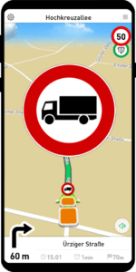
The truck GPS navigation MapTrip Truck calculates the best truck routes taking into account the stored vehicle attributes such as length, width, height, weight and takes into account special features of the cargo, such as whether hazardous goods are loaded. If a driver enters a road that is closed for trucks, he also receives a visual and acoustic warning signal.
Do not save at the wrong end
Free GPS navigation systems such as Google Maps do not have special truck routing, nor do they have the option of storing vehicle profiles with the individual vehicle attributes. This means that a 40-ton truck is guided along the same routes as a passenger car. In practice, however, this ends at the latest before the next low bridge, which is actually predictable.
In the meantime, many forwarding companies have realized that special truck GPS navigation saves time and thus money. But there is also a wide range of GPS navigation providers.
Isn’t a navigation device with truck GPS navigation in the cockpit enough?
Hanging a navigation device with a special truck GPS navigation in the driver’s cockpit is already a start. At least the routes are now calculated with a special truck profile, i.e. on roads that are suitable for large vehicles.
Investing money wisely: Integrated GPS navigation software
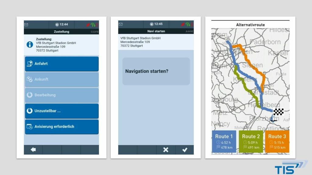
TIS controls MapTrip directly via its own software TISLOG. Both apps communicate with each other via an interface. In this way, the driver and vehicle are directly integrated into the IT infrastructure, i.e. into logistics processes such as order processing, goods tracking and fleet management.
Direct destination transfer from dispatching — drivers no longer type themselves
Dispatchers have numerous advantages with a navigation system integrated into the telematics system. For example, destinations can be transferred directly from the dispatching department to the truck navigation system. As a result, drivers no longer have to type in destinations themselves and can concentrate completely on the traffic and driving.
Accurate ETA calculation, indication of congestion and appropriate re-routing
TIS GmbH calculates the ETA (Estimated Time of Arrival) on its own servers.
Dispatchers have an exact planning basis and can query the calculated time of arrival (ETA) at any time. This means that you can provide information to your customers at any time.
The MapTrip GPS navigation software has a particularly efficient way of calculating congestion avoidance. Real-time traffic information is taken into account for all road sections, not just on the actual congestion route. This makes it possible to calculate the best (= fastest) routes for the respective traffic reports, avoid traffic jams and provide a much more accurate arrival time.
The routes are constantly checked in order to be able to react to a changed traffic situation. If a faster route is available, the driver is informed accordingly.
Always up-to-date map material and a large selection for different regions
As long as there is a mobile data connection, the routes are calculated online on MapTrip servers. This enables the inclusion of the extensive traffic data.
The latest map data is always available on the servers. As a result, TIS has to perform map updates on the devices much less frequently, sometimes at great expense. The locally installed data on the end devices is of course always compatible with the data on the servers.
Only if there is no mobile data connection, the routes are calculated offline, with the map data installed on the devices.
Show truck parking
Parking is an important issue for truck drivers. That’s why drivers especially appreciate the integrated truck parking spaces in the MapTrip app. With one click, they can view the nearest parking lot along the route or search for parking spaces and navigate to them. In terms of color, it is easy to distinguish in the parking space display whether it is a simple parking space, a rest area or car yard. The respective comfort equipment of the truck parking lot is also indicated, i.e. whether there is a gas station, showers or a restaurant.
Close or avoid roads
The big advantage of the integrated MapTrip GPS navigation software are the numerous special functions, which are available for an additional charge.
For example, roads that should not be traveled at all or at certain times can be blocked in the map in a web editor. The closures are then automatically taken into account in the route calculation and bypassed.
Roads can also be avoided. For example, if you have loaded a fragile load and want to avoid a road with many potholes, you can avoid it.
Edit truck attributes yourself in the map
With the Detour function, truck attributes such as length, width or tonnage restrictions that are incorrectly stored or not stored at all on the map can also be edited with one click in the web editor. If a clearance height is not stored for a bridge, for example, it can be easily added. With these additional modules, telematics providers such as TIS GmbH do not have to wait for the next map release from the map data providers.
Further information can be found at:
TIS Technische Informationssysteme GmbH
Müller-Armack-Str. 8
46397 Bocholt