New Release GPS Navigation App 5.4 / SDK 9.4
Changelog
About this release
For this release, we have put the focus on developers working with the MapTrip SDK. The new QuickUI dramatically simplifies the integration of GPS navigation features into your own app. This makes the SDK a very attractive alternative for those who have always wanted to have destination guidance in their own app, but have shied away from the development effort.
By reducing the volume of data transferred, we are significantly reducing the cost of running MapTrip. Also, the improvements around the administration of MapTrip simplify updates and lead in total to the fact that MapTrip is even easier and thus cheaper to operate in the professional environment.
General
Update MapTrip to the latest Android technologies
MapTrip has been updated to the new Android technology Android SDK 31. This means that MapTrip is technologically up to date and stable.
Data consumption minimized
We have been able to reduce MapTrip’s data consumption by 30–40% in online-only mode.
MapTrip regularly updates the traffic situation as well as speed cameras and fuel prices. When route guidance is active, MapTrip also loads the route from the server and updates it regularly (checking for traffic jams, faster route and current arrival time).
With a usage of 100h and 5000km per month, the data consumption (pure online usage without downloaded maps) is about 185MB. Previously, it was about 270MB.
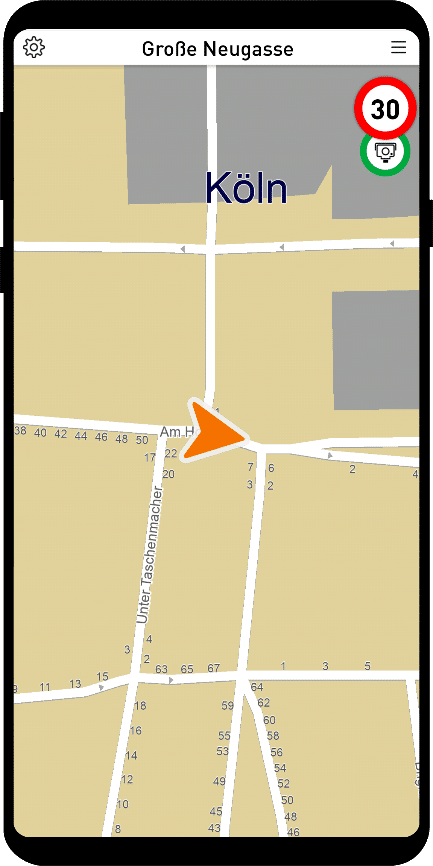
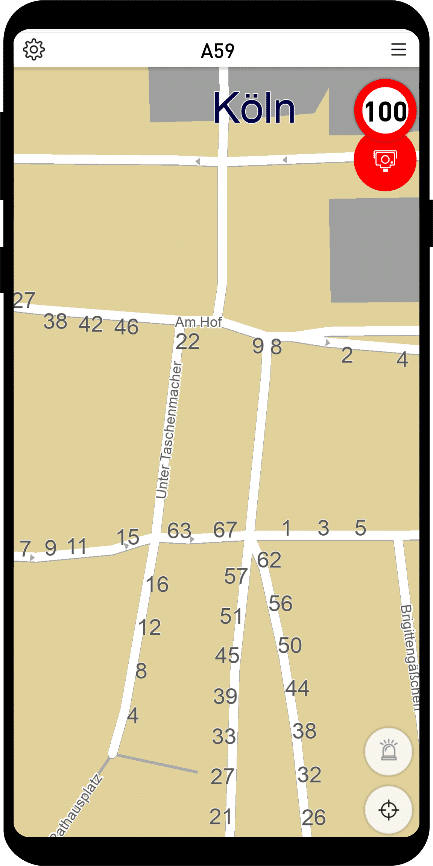
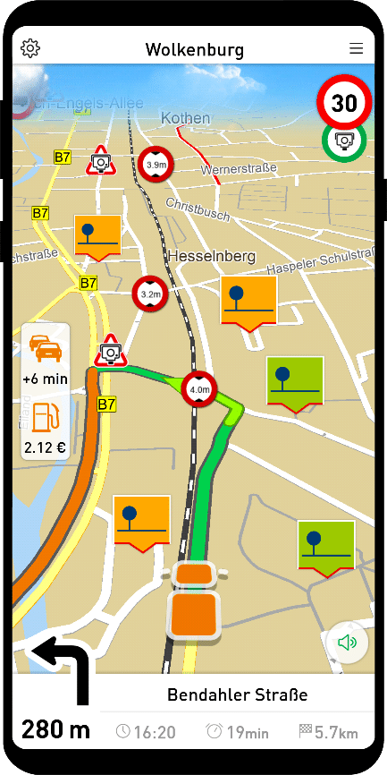
Show house numbers on the map
House numbers can now optionally be displayed on the map. The display can be switched on in the options or alternatively in the settings.ini.
If you add the entry ShowHouseNumbers=1 in the Settings.ini in the section [APPLICATION], the house numbers are always on and you cannot change anything in the MapTrip menu.
[APPLICATION]
ShowHouseNumbers=1
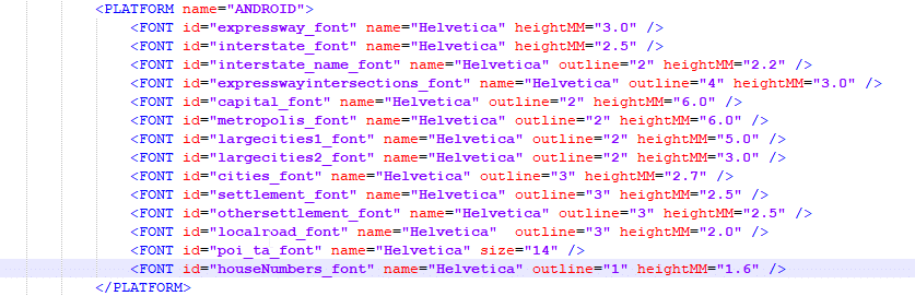
In the mapservices.xml in the section Platform, for example on Android, change the size of the house numbers:
SDK
QuickUI — Integrate navigation into your own app in just one day
With the new QuickUI Library, you can upgrade your app with full-fledged GPS navigation functions with minimal effort.
The QuickUI module provides all basic GPS navigation functions such as map display and turn-by-turn announcements out of the box, dramatically reducing development time.
The module is intended for use cases in which an existing app is to be supplemented with destination guidance.
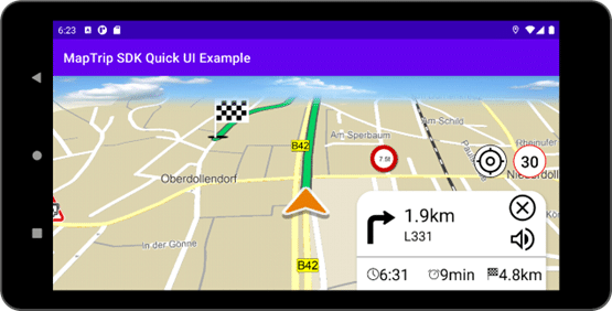
QuickUI provides the following features ready to use:
- Route information: remaining distance & time, ETA.
- Next instruction: direction and remaining distance
- Speed limit display
- Voice guidance with TTS or audio files
- Automatic switching between day and night mode
- Button to resume location tracking
- POI display: traffic events, traffic flow & speed cameras, truck restrictions
- Setting options: Sound output, TTS, day-night mode.
Set multiple listeners
For most classes of the SDK, multiple listeners can now be set, since nowadays it is often necessary to be able to respond to callbacks at several points in the application.
For example, using the Navigation class:
Navigation::addNavigationListener(NavigationListener listener)
Navigation::removeNavigationListener(NavigationListener listener)
Navigation::removeAllNavigationListeners()
Previously, you could only register a listener via registerNavigationListener().
Callback for day-night switching by time of day
If you as a developer of your own UI want to develop different colors depending on the day-night mode of the mapviewer, it is necessary to notice when the mapviewer changes it automatically.
For this purpose the general callback of the ApiListener provides two new values:
GeneralCallbackType.NIGHT_MODE -> Set UI to night mode.
GeneralCallbackType.DAY_MODE -> Set UI to day mode
Show house numbers on the map
Using the MapTrip SDK, the house numbers can now be shown and hidden in the respective mapviewer. For this purpose there is the method:
mapviewer.showLayer(“mmHouseNumber” , true)
Cross-platform .NET development with Xamarin
The SDK is now also available in a Xamarin version. This allows cross-platform applications to be developed for Android and iOS, for example.
Query active detour file
The SDK now offers the possibility to check which detour file is currently active. Individual changes to the street maps are stored in a Detour file. The following properties can be changed with Detour, for example:
- Lock street
- Unblock street
- Prioritize street
- Avoid road
- Truck attributes (length, width, height, weight, etc.)
- and much more…
Waypoints label
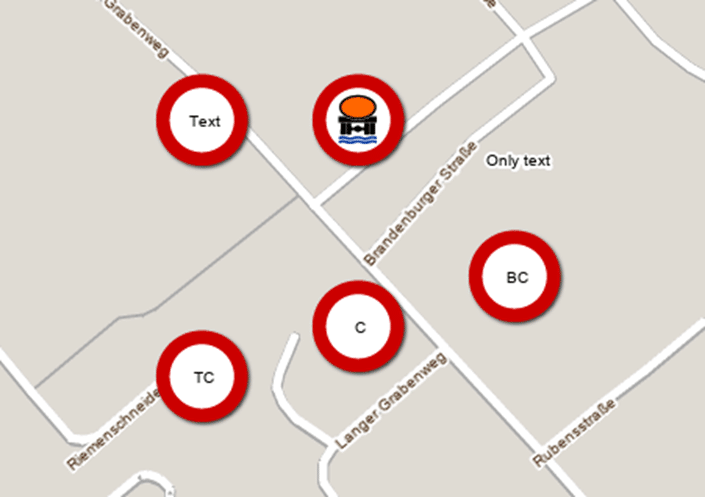
With the MapTrip SDK POIs can be displayed on the map. Since SDK version 9.4 these can be displayed not only with icon, but also with icon and text or only as text.
Each POI can have its own icon and its own text. Additionally it is possible to define per POI how the icon is drawn to the geographical position; i.e. if it is centered, left-aligned, right-aligned etc. (poiAlignment).
The picture shows six (!) POIs:
- Top left: Icon and text
- Top center: Only with icon
- Top right: Only with text
- Bottom left: With top center alignment
- Bottom center: With Center Alignment
- Bottom right: With Bottom-Center Alignment
FollowMe
Suchfunktion in MapTrip
Many FollowMe users have a large number of FollowMe routes in their system. Therefore, it has become necessary to provide a search function for the correct FollowMe route.
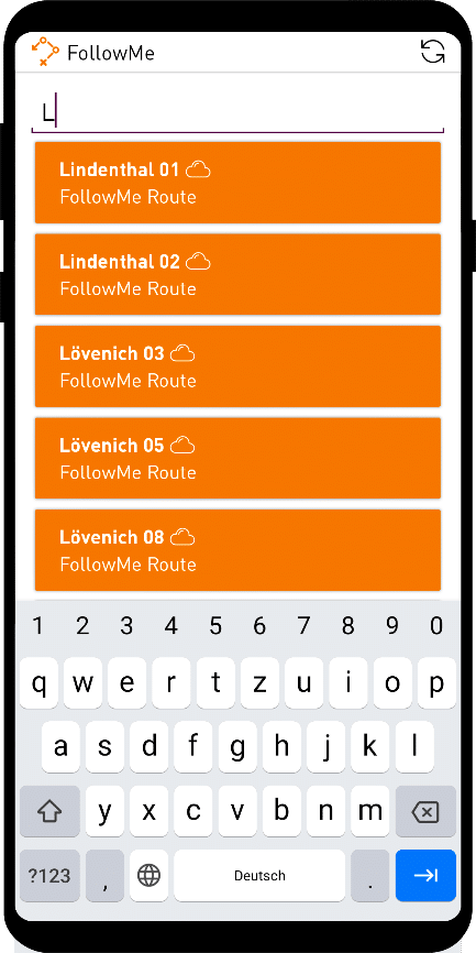
In the FollowMe dialog there is now an easy way to search FollowMe routes. The search is done across all FollowMe folders.
Server-API
Capture streets
In the Server API there are now functions for capturing (for drawing) new roads. This function was already available in the Detour editor. It is suitable e.g. for the capture of new building areas or for the drawing of paths on company premises.
Tutorial for capturing new roads with the Server API — click here.
Time-dependent locks
The function allows to activate changes (e.g. a closure or restriction to one direction of traffic) on roads only in defined time periods, such as
- next week from Monday to Friday
- every Monday from 08:00 to 17:00
- etc
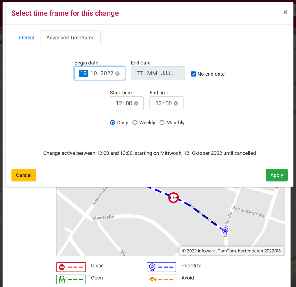
The feature was previously available in the Detour editor and has now been integrated into the Server API as well.
Administration
Run MapTrip with MDM
Normally, MapTrip downloads a new map release automatically — after confirmation by the device user — if the relevant devices have previously been marked for an update in MapTrip Manager.
Users who manage their devices via Mobile Device Management (MDM) can disable the triggered map download and transfer the new map data via MDM or manually at a time of their choosing.
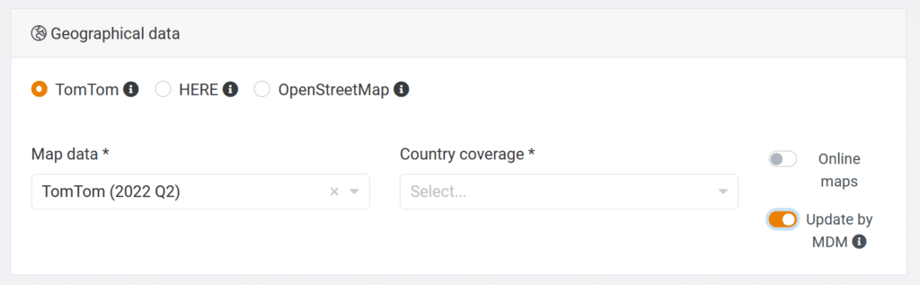
For this purpose, the “Update by MDM” switch can be activated in the MapTrip Manager in the APK creation. A MapTrip installed in this way allows its own map update management, e.g. via MDM.
Update MapTrip easily
In order to install a new version of MapTrip, map data and individual settings files had to be backed up first. After installing the new MapTrip version, these had to be copied back to their original directory.
Since this process was time-consuming and error-prone, we have implemented a significant improvement here. With the new version 5.4, the APK can be installed immediately. It is no longer necessary to backup map and user data beforehand. This makes it much easier to use MapTrip, especially with large fleets of devices. The following folders are backed up: “user”, “data”, “routes”.
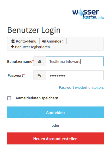
“Wasserkarte” — Water map integration
Users of Wasserkarte.info can import their content (e.g. locations of hydrants) directly into MapTrip. The hydrants are displayed on the map, are searchable as POI and can be navigated directly.

For the integration in MapTrip a link to an account at wasserkarte.info is deposited via the MapTripManager.
To do this, you first register with wasserkarte.info:
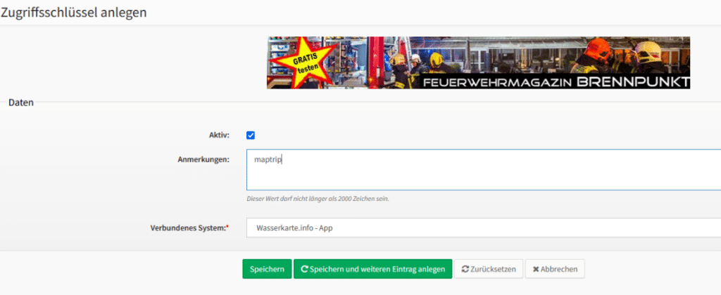
Under “Access keys”->“Create access key”, enter “maptrip” under Notes:
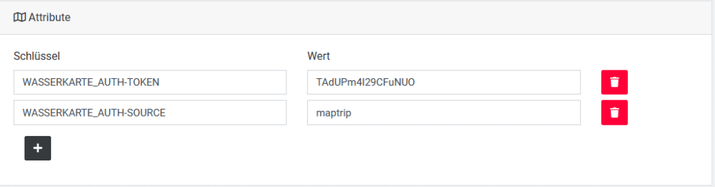
The key created in this way can then be stored in MapTripManager at the company:
The functionality is then activated for the devices as a new license option:

In MapTrip, the recorded data are then available as POIs. If the wasserkarte.info app is installed, you can easily switch to the app with a click, where all details of the respective object are displayed.