Business Navigation
Navigation for winter service — The Real Pac-Man?
Business Geomatics reports on the cooperation between info-tech solutions GmbH & Co. KG and infoware. Read more about the practical use of MapTrip FollowMe Navigation for municipal winter service and street cleaning.
With MapTrip FollowMe, infoware Informationstechnik GmbH has developed a navigation for waste management, winter service and street cleaning. Building on this, info-tech solutions has developed further features. We have translated the article for you here.
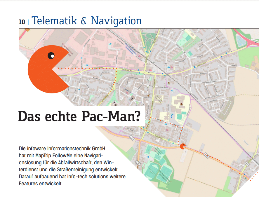
A vehicle drives seemingly at random across a digital road map — and collects large, colourful balls in the process. What is reminiscent of the 1980 classic game Pac-Man is actually an innovative navigation system from infoware Informationstechnik GmbH in Bonn. “MapTrip FollowMe was developed directly from practice for practice,” reports Volker Wickenkamp, Head of Sales at infoware.
“What is important for the drivers of vehicles from waste disposal, winter service or street cleaning when navigating? What special needs do they have? How could these challenges be met? Our goal was to create a solution that provides answers to all these questions.”
This has resulted in the development of MapTrip Follow Me. The product name already shows where the journey is heading: Based on a Follow Me car, which guides aircraft to their position in airport operations, the infoware solution is also intended to support vehicle drivers in their route finding.
“Of course, this then goes beyond simply navigating the drivers,” explains Wickenkamp. “It is eminently important, for example, that drivers can drive along sections of a route several times. After all, these loops are part of the daily routine of many vehicle drivers in the municipal sector.”
Off-road function for unmapped areas
But the possibility of being able to create a route for regions that have not yet been mapped — especially new construction or commercial areas — is also important. “In order to be able to navigate vehicle drivers safely through road areas that have not yet been mapped, we developed the off-road function at MapTrip FollowMe,” he said. “With one click, this is activated and then records the route,” Wickenkamp explains. In the map display, drivers leave the road area in these cases, but the route is still displayed normally.
In addition, both drivers and dispatchers can store notes on special features, instructions or hazard warnings in MapTrip FollowMe. “ ‘Caution, biting dog’, ‘Reverse’ of ‘Garbage cans are behind the hedge’ — there are no limits to the imagination,” says Wickenkamp.
In this way, companies should ultimately be able to use alternating drivers on the route. “Imagine the driver of a certain route is ill or on holiday. The replacement driver now has to drive the route for the first time and is not familiar with the area. With our solution, he still gets all the information he needs to complete his tour efficiently,” reports the infoware sales manager.
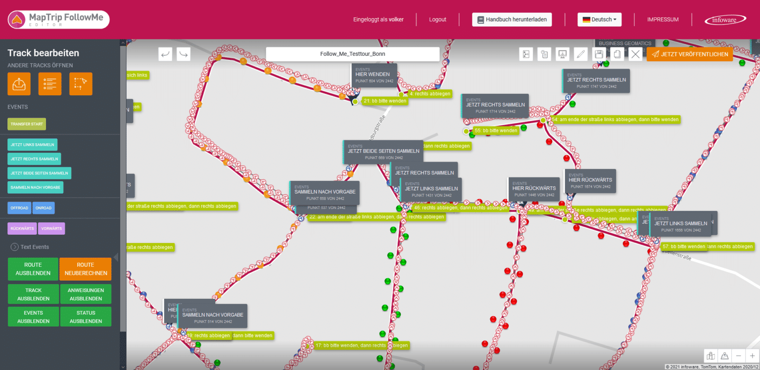
To integrate such hints into the solution, they only have to be stored in the web-based MapTrip editor. “The location of the hint also plays an important role. In the end, the hints are displayed — and even read aloud — to the driver exactly where they have been stored in the editor,” Wickenkamp summarises. Alternatively, drivers can also place such notices on the route. All they have to do is operate the corresponding function in the MapTrip FollowMe app. “App operation while driving is of course difficult. Therefore, we have integrated popular hints directly into the app in a quick dial system. Drivers can then simply select them in the right place.” They can also create individual information texts and add them to the quick dial.
Special requirements = special solutions
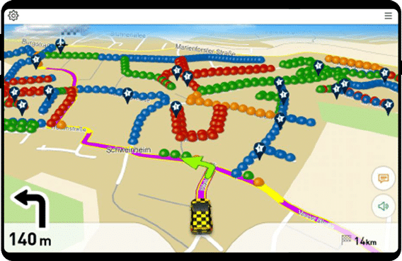
“In addition, there are the special requirements of the respective areas. In the case of waste disposal, for example, when a pure transport trip is due or on which side of the road and at which point the bins are to be collected,” Wickenkamp reports. To meet these requirements, infoware has sometimes come up with special solutions: The bins to be collected, for example, are represented by different coloured balls — red “bubbles” point to the right side of the street, green to the left.
“The Pac-Man comparison is also based on this representation,” Wickenkamp smiles. In general, infoware uses colour coding in many places to ensure intuitive operation of the navigation for winter services, street cleaning and waste management. For example, upcoming transport journeys — i.e. route sections on which the vehicles only have to make the transfer in order to drive to the waste disposal site, for example — are highlighted in purple, while changes of direction are shown in light green. “With MapTrip FollowMe, the colour scheme allows drivers to see at a glance which obstacles, special features and tasks they will be facing. This makes everyday work easier,” Wickenkamp reports.
MapTrip editor as basic framework
The basis of the functions is the creation of a so-called GPS track in the MapTrip editor. In this process, the individual GPS points of the route are combined to form a track. “Of course, such a GPS track can also simply be uploaded into the MapTrip editor in .csv data format,” says Wickenkamp. Here, the individual GPS points are then moved or deleted by clicking. “This way you can pre-plan the routes in the browser and place annotations in the right places.” After the route has been saved and the FollowMe app has been resynchronised, the driver can call up the route on his Android device. The communication between the app and the web browser works via mobile radio.
In the future, infoware also plans to integrate further functions into MapTrip FollowMe. In the new version 4.11, which is scheduled for release at the end of April/beginning of May, dispatchers will, for example, have the option of monitoring vehicles in real time. “This is a sought-after function for the purpose of hazard monitoring, especially for winter services. Such further developments of the solution are also included in our monthly rental price,” says Wickenkamp.
Partnership for navigation in winter service
In response to this pressure to innovate, the Bonn-based company is working with partners who also come from the field of municipal telematics. For example, with info-tech solutions GmbH & Co. KG. In addition to in-house developed on-board computers for municipal commercial vehicles, the company from Feldberg in the Black Forest offers, among other things, the software solution DNAS3, into which the infoware navigation for winter service can be integrated.
With our software, all work of the equipped vehicles can be recorded with place and time”, reports Dennis Linhardt from info-tech sales. “It doesn’t matter whether spreaders or mowers are used, for example. We can record any attachment and attachment equipment as well as transport journeys.” By storing geographical information, the work can then even be automatically assigned to specific cost units or clients.
In addition, an integrated billing module allows hourly rates to be developed for each activity, based on the material, personnel and machines used. “An example of this: Imagine a company receives an order to clear the snow from a supermarket car park. In our DNAS solution, the company can now define the car park as an object. Once recorded, the values for gritting area, space area, time spent, salt consumption and more are automatically determined and assigned,” says Linhardt. In this way, the template for a monthly invoice, for example, can already be created at the push of a button.
“However, the solution is not limited to winter services,” reports the info-tech sales representative. “Rather, the software consists of many modules that can be individually combined depending on the requirements. This means that DNAS can also be used, for example, for green maintenance, playground control, street cleaning and much more.
On-board computer with GPS reception
The potential of the info-tech software for municipal journeys becomes particularly clear when the solution is combined with the on-board computers of the company from Feldberg: “Of course, it depends on what the customer wants to record. But in principle, every municipal commercial vehicle needs an on-board computer with a GPS receiver.
Here the range extends from our Primus, which can be used universally, to the small computer Fificus, which is suitable for smaller equipment such as ride-on lawnmowers, to the Portus II, a mobile handheld that is ideal for recording manual work and columns,” says Linhardt. As a result, the on-board computers are used to record the running, operating and standing times of the vehicles, so that companies not only fulfil their logging obligation, but also have a planning tool at their disposal that brings about a sustainable increase in efficiency.
“The information collected can then be projected onto GIS data. This can be conventional road maps or map material provided by customers as well as the navigation MapTrip FollowMe from infoware,” Linhardt reports. The operation of the software solution is intuitive, standard tasks are “easy to handle with our software. However, if you want to get the most out of it, you should familiarise yourself with the system or get the appropriate support,” says the sales representative. The Feldberg-based company offers training courses and seminars for this purpose. (jr)
info-tech solutions – Professional telematics solutions.